
Specialization:
MS Thesis
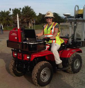
Using Laser Scanning Technology to Monitor Coastal Erosion
Advisor
Alex Simms
Bio:
Eva von Thury began her career as a Project Geologist/GIS Analyst for Padre Associates since March 2014. Prior to that she has been employed by Fugro Consultants, Inc. from 2006 through 2014, as a GIS Analyst/Staff Geologist. While maintaining full-time employment at Fugro, Eva continued her graduate studies in Geological Sciences from the University of California, Santa Barbara (UCSB) under the advisement of Professor Alex Simms. Eva has completed the masters program and officially earned a Spring 2013 MS degree. Eva's research involved using LiDAR and Dynamic Laser Scanning (DLS) to monitor coastal erosion in Southern Santa Barbara County and develop annual rates of retreat.
In 2005, Eva obtained her Bachelor of Science degree from UCSB in Environmental Studies. Eva continues to work for Fugro Consultants, Inc. and has had the opportunity to work on wide range of global projects, performing field work throughout North America. Below is a sample list of some major projects that Eva has worked on for Fugro since 2006.
Project Experience:
- Kearl Expansion Project (KEP) – Ore Preparation Plant 2E Area Project, Fort McMurray, Alberta, Canada. Construction project for the expansion of existing oilsand mine. Provided engineering QA for:pile deep foundations; K2 mechanically stabilized earth (MSE) wall, 18 meters in height; borrow source material evaluations; general earth work activities; and foundation and excavation inspections. Collected, reported, and analyzed instrument data (i.e. piezometer, inclinometer, strain gage, and extensometer) K2 MSE Wall.
- Syncrude Aurora Mine Relocation Project, Fort McMurray, Alberta, Canada. $1.6 billion construction project (original projected cost) for the relocation of Imperial Oil’s active oilsand mine. Provided engineering QA for: drilled shaft foundations; redesign and evaluation of piles; the new Train 2 and Train 3 mechanically stabilized earth (MSE) walls, each 18 meters in height; borrow source material evaluations; general earth work activities; and self-propelled mobile transport (SPMT) routes. Collected, reported, and analyzed instrument data (i.e. piezometer, inclinometer, strain gage, and extensomete from Train 2 and Train 3 MSE Walls.
- Municipal Water District (MWD) Switch Houses Seismic Upgrade Project - Rock Coring Fieldwork, Indio, California. Three pumping plants along the Colorado River Aqueduct that deliver water to Southern California. Logged rock cores to determine depth to competent material for seismic upgrade at Eagle Mountain facility.
- University of California, Santa Barbara Santa Catalina Housing – More Ranch fault. Assisted the field geologist in fault trenching, soil coring, and CPT field work for new building construction. GIS data management and mapping of exploration and fault data.
- Norfolk Southern Rail Network and General Implementation of GIS, John Chance Land Survey’s (Fugro JCLS) Corridor Mapping (CM). From October 2008 to December 2011, Ms. von Thury worked as a GIS Analyst and educator with Fugro’s Corridor Mapping Group in Lafayette, Louisiana. The Corridor Mapping Group (CM) operates the Fli-Map LiDAR Survey collection system. In this role, she developed systems for efficient and expanded deliverables for the Norfolk Southern Rail Network project and trained Fugro JCLS staff members in use of the systems. During the course of her secondment to Fugro JCLS, she achieved the following major tasks:
- Worked with sde data to build a GIS rail network database for the Norfolk Southern project;
- Made mobilization maps for field crew use;
- Designed and taught basic GIS skills to group members and worked with project managers to set up a general GIS project database for project management;
- Assisted Flip-7 (FLI-MAP® Software) developers in making the software’s outputs more GIS ready;
- Provided GIS support for clients (Norfolk Southern);
- Set up an ArcGIS Explorer map for viewing project data that is accessible for use by all members of the CM Group
- Designed and presented ArcGIS Explorer training classes for the CM Group; and
- Collaborated with the field crew and a programmer to create a GIS tool that automates the generation of monument maps in ArcMap and subsequently stores the maps in a GIS database for initial field use and reference at a later date.
- Levee Geotechnical Evaluation Project, Department of Water Resources, California Department of Water Resources. GIS Lead Analyst coordinating work for geotechnical evaluations of three site areas (Reclamation District 17, Reclamation District 404, and Natomas) for a $35 million contract to evaluate 350 miles of levees that protect urban communities. GIS is being used to illustrate the subsurface and surficial characteristics of the levees to enhance engineering analysis. Work includes building a GIS database with data gathered from site reconnaissance; review of historic levee performance; drilling and sampling of exploratory borings and cone penetration tests; open standpipe piezometers; and laboratory tests performed on retrieved soil samples.
- The data is stored in gINT and GIS databases for support in engineering analyses, preliminary design, and construction cost estimates for upgrading the levees to FEMA certification. GIS data management and mapping includes working with high density topographic data obtained with Fugro's FLI-MAP® system, Helicopter Electromagnetic (HEM), and Magnetometer data, enhancing site characterization and graphic presentation/reporting of levee profiles and local geology.
Publications:
- Coast Geologic Society (CGS) speaker December 2012: Using laser scanning technology to evaluate coastal erosion and sea-cliff retreat in Southern Santa Bambara County.
- ASBPA Speaker 2012: Using laser scanning technology to evaluate coastal erosion and sea-cliff retreat in Southern Santa Barbara County.
- ESRI User Conference Map Gallery Presenter 2006: Ventura County Mountain Rainfall Contouring; 2008: Evaluation of Northern California Levees; and 2013: Using Laser Scanning Technology to Evaluate Coastal Erosion and Sea-cliff Retreat is Southern Santa Barbara County.